
Tours stopping at Roberton Island
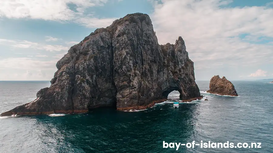
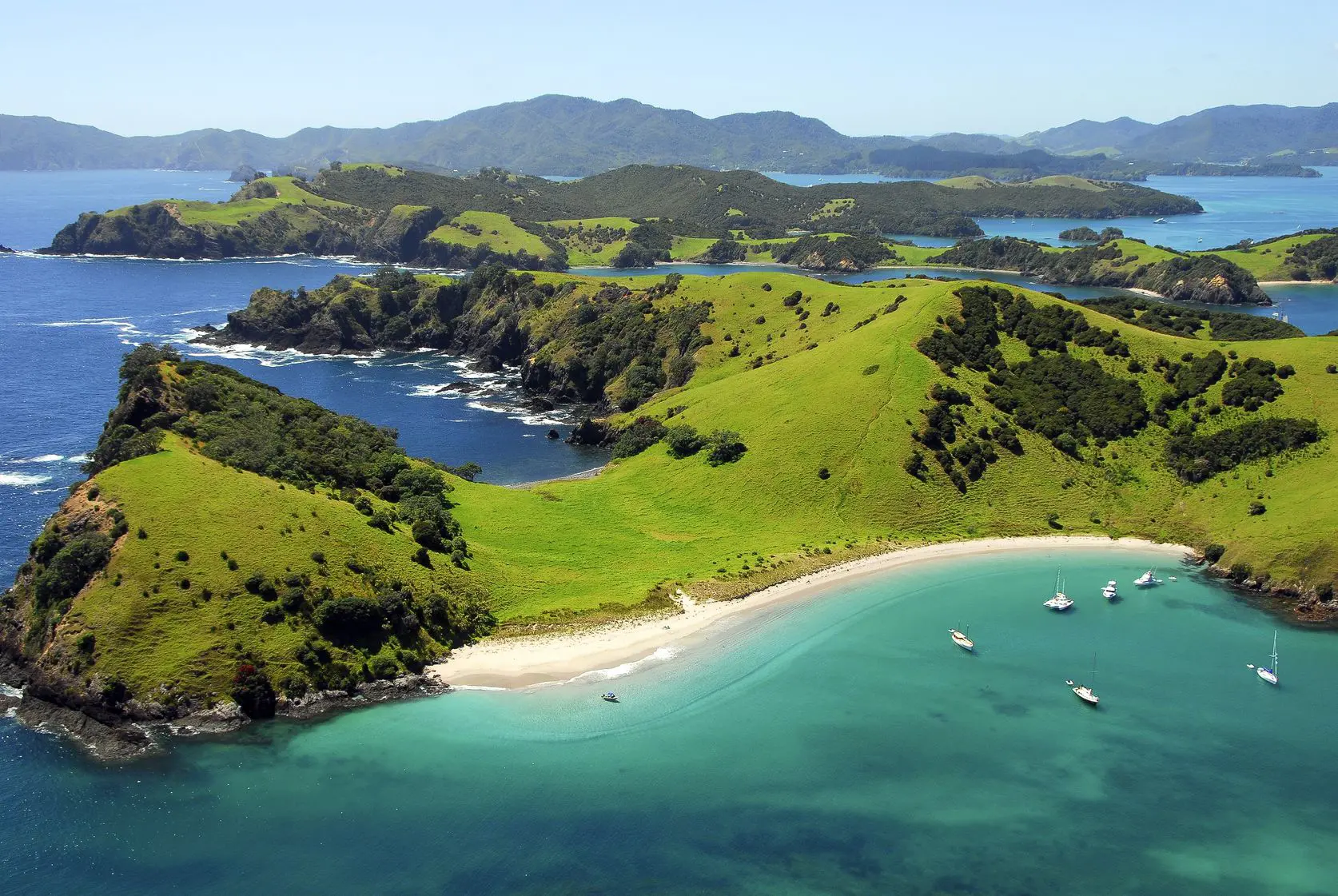
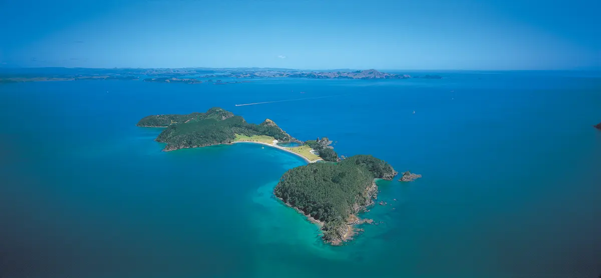
Roberton Island, known by its Māori name Motuarohia (meaning “reconnoitred island”), is home to the Bay of Islands’ most iconic image – twin lagoons of crystal-clear turquoise water sheltered by dramatic coastal scenery. This small island approximately 4 kilometres northeast of Russell presents two completely different characters: rugged cliffs rising to 78 metres dominate the northern coast, while the southern side offers sheltered lagoons and golden beaches perfect for swimming and snorkelling.
Since 1979, the central 19.4-hectare section including the lagoons has been managed as a Recreation Reserve, while the remaining 44 hectares remain in private ownership. Thanks to Project Island Song’s pest eradication efforts, the island is now pest-free, allowing rare native birds including whiteheads, North Island brown kiwi, and New Zealand dotterels to thrive. A 15-minute uphill walk from the lagoons leads to a lookout offering spectacular 360-degree views across the Bay of Islands, while an educational underwater snorkel trail provides marine interpretation in the calm lagoon waters. Whether visiting for a few hours on a cruise stop or exploring for a full day, Motuarohia delivers the quintessential Bay of Islands island experience.
Why Roberton Island Matters
Motuarohia’s significance spans from prehistoric Māori settlement through pivotal cultural encounters to modern conservation success. Archaeological evidence shows continuous habitation from the earliest Polynesian arrival, with ancient pā sites, terraces, pits, and gardening lines scattered throughout the central lagoon area.
In November 1769, Captain James Cook anchored the Endeavour in what is now Cook’s Bay on the island’s northern coast. The island was inhabited by up to 300 Māori who were initially hostile, though peace was eventually restored – one of the first significant encounters between Māori and Europeans in Northland.
In 1839, whaling captain John Roberton purchased Motuarohia from Ngāpuhi chiefs, giving the island its English name. Tragically, Roberton was killed in a boating disaster in 1840. The following year, in November 1841, his widow Elizabeth Roberton, her two children, Robert Bull, and Isabella Brind (granddaughter of Ngāpuhi leader Rewa) were murdered by Maketū Wharetōtara, the 17-year-old son of Ngāpuhi chief Ruhe. Maketū became the first person to be legally hanged in New Zealand under British law in 1842 – a grim milestone in the country’s legal history.
The Crown acquired the central section in 1979, designating it as a Recreation Reserve. Project Island Song’s successful pest eradication has made Motuarohia pest-free, allowing native forest regeneration and the return of rare native birds. For tangata whenua, Motuarohia remains a place of deep cultural significance.
What to See & Do on Roberton Island
Twin Lagoons Bay
Twin Lagoons Bay on Motuarohia’s southern coast is the island’s main attraction and access point for most visitors. The two lagoons – separated by a narrow strip of land and nearly reaching across to the northern coast – create the Bay of Islands’ most recognizable and photographed scene.
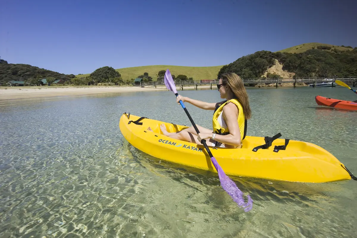
The western lagoon serves as the main landing area for commercial cruises and water taxis, with a small beach where boats can discharge passengers. The calm, shallow waters make swimming safe and enjoyable even for families with young children. The clarity of the water is exceptional, allowing visibility of the sandy bottom and marine life even from the beach.
The eastern lagoon is slightly more secluded and deeper, offering excellent snorkelling conditions. The sheltered position means calm water even when the outer bay experiences swells. At high tide, both lagoons fill completely, creating ideal swimming and snorkelling conditions. At low tide, extensive sandy flats are revealed, perfect for beachcombing and exploring tidal pools.
The contrast between the tranquil southern lagoons and the dramatic northern cliffs – visible from the beach or the lookout track – showcases the island’s dual nature and adds to its visual appeal.
Underwater Snorkel Trail
DOC has established an educational underwater snorkel trail in the calm waters of the eastern lagoon, making Motuarohia one of the few places in New Zealand with underwater interpretation. The trail features underwater plaques that snorkellers can follow to learn about the marine ecosystem, fish species, and conservation efforts in the Bay of Islands Marine Mammal Sanctuary.
The sheltered lagoon provides ideal conditions for beginner and experienced snorkellers alike. The clear water, gentle conditions, and abundant marine life make this an accessible introduction to the Bay’s underwater world. Common sightings include various reef fish species, sea urchins, and occasionally stingrays gliding over the sandy bottom.
Visitors should bring their own snorkelling gear, as rental equipment is not available on the island. The eastern side of the island also offers good snorkelling, though rocks can be sharp – reef shoes or aqua socks are recommended.
Lookout Track
The 15-minute uphill walk from the western end of Twin Lagoons Bay to the central lookout is moderately challenging but absolutely essential. The track involves approximately 200 steps and steady climbing, gaining 118 feet of elevation over about 0.8 kilometres (0.5 miles).
The reward at the summit justifies every step: spectacular 360-degree panoramic views encompassing the entire eastern Bay of Islands. From this vantage point, you can see Cape Brett and the Hole in the Rock to the northeast, Russell and the Bay of Islands township to the south, Waitangi and Paihia to the southwest, and countless islands scattered across the blue water. Looking down, the twin lagoons appear even more dramatic from above, with their vivid turquoise water contrasting against white sand and dark native bush.
The lookout also provides views toward the dramatic northern cliffs and the channel between Motuarohia and neighbouring Moturua Island – a designated marine mammal safe zone where special vessel restrictions apply.
Interpretation panels at the lookout explain the view, the island’s natural history, and Project Island Song’s conservation work. The track is well-maintained and suitable for most fitness levels, though the steps and gradient make it moderately challenging. Allow 30-40 minutes return from the beach.
Pā Site Track
A separate walking track leads from the lagoon area to a historic pā site, offering insights into the island’s Māori history. The fortified pā demonstrates the strategic importance of Motuarohia’s elevated positions and protected anchorages. Archaeological features including terraces, defensive ditches, and living areas remain visible, with interpretation signage explaining the site’s significance.
DOC undertook track upgrades and pine removal around the pā site in 2019 to enhance visitor experience and make historical features more visible, particularly for the Tuia 250 commemorations marking 250 years since Cook’s visit.
Wildlife & Conservation
Motuarohia’s pest-free status has enabled remarkable native wildlife recovery. The island is now home to whiteheads (pōpokotea), often called the “canaries of the forest” for their distinctive calls. These small native birds can be heard and occasionally seen throughout the island’s regenerating forest.
North Island brown kiwi have been introduced to the island as part of Project Island Song, though as nocturnal birds they are rarely seen by day visitors. New Zealand dotterels (tūturiwhatu) nest on the island’s beaches, with DOC implementing protection measures during breeding season (typically September to March).
The topography supports diverse habitats: steep coastal cliffs with pōhutukawa and coastal tussock, regenerating native forest dominated by hangehange and coprosma species, kikuyu grass flats, and the unique lagoon environment. Maritime pine (Pinus pinaster) stands are being gradually removed to allow native forest regeneration.
The surrounding waters are part of the Bay of Islands Marine Mammal Sanctuary, with common bottlenose dolphins frequently spotted in the channel between Motuarohia and Moturua. The marine mammal safe zone between the islands implements special vessel speed and approach restrictions to protect dolphins.
Practical Info: Getting There & Visitor Tips
Getting There
Motuarohia Island is accessible only by water – there is no land access. Most visitors arrive via commercial cruise operators from Paihia or Russell.
By Commercial Cruise: Most Bay of Islands sightseeing cruises include a stop at Motuarohia’s Twin Lagoons Bay, typically allowing 1-2 hours ashore. Popular operators include Explore Group’s “Hole in the Rock” cruises and various other day cruise options. These typically combine Motuarohia with visits to other islands and attractions like the Hole in the Rock at Cape Brett. Check-in is typically at the Maritime Building in Paihia or Russell Wharf.
By Private Boat or Kayak: Motuarohia is approximately 10 minutes by boat from Rawhiti boat ramp or 15-20 minutes from Russell. The sheltered lagoons provide good anchorage. Very experienced kayakers can reach the island from Russell or nearby anchorages – the crossing is exposed and should only be attempted in calm conditions with appropriate safety equipment. Remember that boats must follow Bay of Islands Marine Mammal Sanctuary restrictions, and the channel between Motuarohia and Moturua is a marine mammal safe zone with specific vessel rules.
Facilities & Services
What’s available: The recreation reserve has basic facilities including toilets and picnic areas. Interpretation panels and signage explain the island’s natural and cultural history. During summer (typically December-February), rubbish collection facilities may be available, though this is not guaranteed.
What’s NOT available: No café, shop, drinking water, shelter, or any commercial facilities exist on the island. There is no mobile phone coverage. No camping is permitted on Motuarohia – camping in the Bay of Islands is only available on Urupukapuka Island.
What to bring: Sun protection, water (essential – bring at least 1 litre per person), snacks or lunch, snorkelling gear, camera, sturdy footwear for the lookout track, and reef shoes if planning to snorkel on the eastern side. Bring all supplies needed, as nothing is available for purchase on the island.
Critical Biosecurity Information
Motuarohia’s pest-free status requires constant vigilance from every visitor:
Before visiting:
- Scrub all soil off shoes and gear – use cleaning stations if provided at departure points
- Check all bags and equipment for pests, particularly rats, mice, and Argentine ants
- Always stay on marked tracks to prevent spread of weed seeds
- Follow “Check, Clean, Seal” protocols for all gear
On the island:
- Stay on designated tracks
- Do not bring any food items that could introduce pests
- Take all rubbish with you (pack in, pack out principle)
- Report any pest sightings immediately to DOC
The island’s conservation success depends entirely on visitors’ careful adherence to biosecurity requirements. Even a single introduced pest could undo years of restoration work.
Visitor Tips
Time on island: Most commercial cruises allow 1-2 hours at Motuarohia. This is sufficient time to swim in the lagoons, walk to the lookout, and do some snorkelling. For a more relaxed experience, consider a water taxi allowing 3-4 hours on island.
Best time to visit: High tide provides the best swimming and snorkelling conditions in the lagoons. Check tide times before your visit. Summer (December-February) offers warmest water temperatures and weather, but also the most crowded conditions. Shoulder seasons (March-May, September-November) can provide excellent weather with fewer visitors.
Lookout track: While only 15 minutes uphill, the track involves steady climbing and approximately 200 steps. Start early in your island visit before the day heats up. The views absolutely justify the effort – don’t miss it.
Swimming and snorkelling: The lagoons offer safe swimming for most conditions, but always assess conditions on arrival. Supervise children closely. For snorkelling on the eastern side of the island, wear reef shoes as rocks can be sharp.
Photography: The twin lagoons photograph beautifully from the beach, but the aerial perspective from the lookout provides the classic shot seen in promotional materials. Morning light is often best for photography.
Respect private property: Remember that approximately 70% of the island is privately owned. Respect property boundaries and stay within the designated recreation reserve areas.
No dogs: Dogs and other pets are not permitted on the island (except registered assistance dogs) to protect native wildlife and maintain biosecurity.
Weather: The island offers little natural shelter. Bring sun protection on fine days and rain gear if weather is unsettled. The northern cliffs create dramatic scenery but exposed conditions.
Local Listings to Explore
Tours & Activities
Hole in the Rock Cruises Full-day Bay of Islands cruises typically including stops at Motuarohia Island’s Twin Lagoons Bay, the Hole in the Rock at Cape Brett, and often Urupukapuka Island. Dolphin viewing opportunities en route. Operated by various providers including Explore Group.
Browse more Tours & Activities in the Bay of Islands
Accommodation Near Roberton Island
No accommodation exists on Motuarohia Island itself. Visitors base themselves in Paihia, Russell, or other Bay of Islands towns, all offering numerous accommodation options within easy boat access to the island.
Browse Accommodation options in the Bay of Islands
Food & Drink
No food or beverage facilities exist on Motuarohia Island. Bring all food and drinks needed for your visit. For dining before or after your island trip, Paihia and Russell offer numerous restaurants, cafés, and takeaway options.
Map
Sorry, no records were found. Please adjust your search criteria and try again.
Sorry, unable to load the Maps API.