The Bay of Islands offers some of New Zealand’s finest coastal and forest walking, from gentle waterfront strolls to challenging island circuits. Whether you’re after swimming beaches, historic sites, native birdlife, or simply spectacular views, you’ll find tracks that deliver.
This guide covers the region’s best walks, organised by area and difficulty. Most are accessible for families and casual walkers, while others reward experienced trampers with remote forests and rugged coastline.
Paihia & Waitangi
Haruru Falls Walk

6km return | 1.5-2 hours | Easy
The Haruru Falls Walk follows the Waitangi River through mangrove boardwalks to Northland’s horseshoe-shaped Haruru Falls, where a 5-metre cascade spreads across the full width of the river. Starting right from Paihia’s waterfront, the track takes you through tidal mangroves teeming with birdlife, regenerating native bush, and riverside sections with good swimming holes. The falls are impressive year-round, and the combination of easy access, gentle terrain, and varied environments makes this one of the region’s most popular family walks.
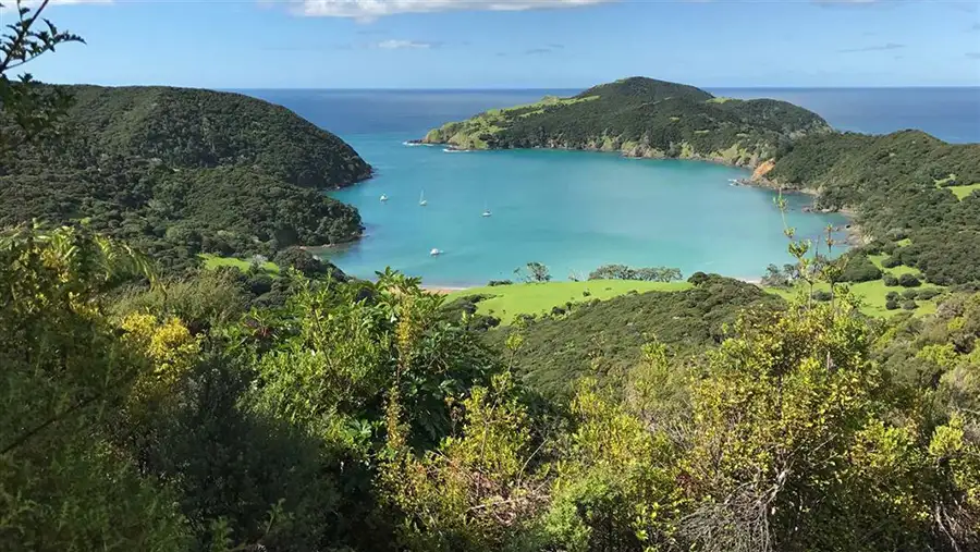
Paihia to Ōpua Coastal Walkway
5km one way | 1.5-2 hours | Easy to moderate
This scenic coastal path hugs the Bay of Islands shoreline between two neighbouring towns, taking you past sheltered bays, through native bush, and over boardwalks positioned just metres above the water. The track stays close to the sea throughout, with constant water views, seabirds working the shoreline, and clear turquoise water typical of the region. You can walk one way and arrange transport back, or complete the full 10km return journey over about three hours.
Paihia School Road Track
2km return | 45 minutes-1 hour | Moderate
Popular with locals for morning fitness, this quick uphill climb through regenerating native bush rewards you with elevated views over Paihia, Waitangi, and the islands beyond. The track gains about 100 metres in less than a kilometre, making it a proper workout despite the short distance. It’s the kind of walk locals do regularly without much thought, while visitors discover it as a pleasant alternative to the busier coastal tracks.
Waitangi Mountain Bike Park
30km+ network | Various times | Easy to moderate
Built primarily for mountain bikers, the Waitangi Mountain Bike Park offers walkers access to over 30 kilometres of smooth, well-maintained trails winding through pine forest and native bush. Ridge-line routes provide Bay of Islands views, while valley loops offer forest immersion. The trails stay quiet on weekday mornings, and because they follow natural contours, the gradients are generally easier than traditional bush tracks.
Russell Peninsula
Flagstaff Hill Track (Te Maiki)
1.5km return | 1-1.5 hours | Easy to moderate
The Flagstaff Hill Track climbs to Russell’s historic flagstaff where Ngāpuhi chief Hōne Heke famously cut down the British flagpole four times in the 1840s. This short but steep climb provides 360-degree panoramas across the Bay of Islands and Russell township below, while interpretation panels explain one of New Zealand’s most dramatic early colonial conflicts. The accessible length, powerful history, and views make this Russell’s most walked track.
Tapeka Point Track
800m return | 20-30 minutes | Easy to moderate
This quick clifftop walk from Tapeka Beach to open headland takes about 20 minutes and provides sweeping views over Roberton Island, Urupukapuka, and the island-dotted bay. The track is short but steep with proper coastal exposure, making it ideal for photographers wanting classic bay compositions or anyone after substantial views without a long walk. Early morning brings the best light and fewer visitors to this deservedly popular viewpoint.
Bay of Islands Coastal Walkway
3km one way | 45-60 minutes | Easy to moderate
The Okiato to Russell section of the Bay of Islands Coastal Walkway threads through regenerating native bush, crosses wooden boardwalks over tidal wetlands, and traces a coastline connecting New Zealand’s first capital with its most notorious early settlement. This peaceful track sees fewer people than Russell’s busier walks, providing proper coastal tramping atmosphere with good birdwatching opportunities. The atmospheric Okiato cable ferry adds character to the journey.
Nancy Fladgate Track
2.5km one way | 45 minutes-1 hour | Moderate
Tucked away on Russell Peninsula’s quieter side, the Nancy Fladgate Track connects Oneroa Bay with Tapeka Road through regenerating forest and elevated coastal sections. This moderate bush and coastal walk provides genuine solitude, elevated viewpoints overlooking the bay, and that sense of discovery that comes from walking tracks that don’t appear on most visitors’ itineraries. The forest immersion combined with coastal views creates something different from Russell’s more popular walks.
Ōpua
Ōpua Forest Lookout Track
1-1.5km return | 30-60 minutes | Easy to moderate
The Ōpua Forest Lookout Track climbs steadily through native forest to a lookout point with filtered views across Veronica Channel and surrounding landscape. This short bush walk provides good birdlife, peaceful atmosphere, and that immersive bush feeling close to town. Locals walk it regularly for their morning nature fix, while visitors appreciate a forest escape that fits easily between other Bay of Islands activities.
Oromahoe Traverse
6-7km one way | 1.5-2.5 hours | Easy to moderate
This cross-country route linking Haruru with Oromahoe Road threads through regenerating native forest, across farmland, and over wetland boardwalks. The walk moves through distinctly different environments as you progress, and the variety keeps things interesting throughout the 6 to 7 kilometres. The solitude is remarkable compared to coastal tracks, and you’re seeing rural Northland beyond the standard tourist corridor.
Kerikeri
Rainbow Falls

200m return | 5-10 minutes | Very easy
Rainbow Falls is Kerikeri’s signature waterfall and one of the most visited natural attractions in the Bay of Islands. At 27 metres, this wide curtain of water plunges over a basalt cliff into a churning pool below, creating impressive scenery in all seasons. The appeal here is the combination of dramatic waterfall and stupidly easy access. You can walk from car park to viewing platform in 5 to 10 minutes on a proper path. On sunny days, mist from the falls creates rainbows in the right light, earning both the English and Māori names.
Wharepuke Falls

2km one way | 30-40 minutes | Easy
Wharepuke Falls sits on the Kerikeri River, accessed via well-maintained forest tracks that wind along the riverbank through native bush. This small but beautifully formed waterfall appeals to families wanting an easy forest ramble and swimmers looking for freshwater pools. The walk forms part of the wider Kerikeri River Track network connecting several waterfalls and swimming spots, so you can extend it if you have more time available.
Kerikeri River Track
4.5km one way | 1.5-2 hours | Easy to moderate
The Kerikeri River Track starts from one of New Zealand’s oldest European buildings and ends at a 27-metre waterfall, with swimming holes and thick native bush in between. This 4.5km path follows the Kerikeri River through the heart of town, providing accessible walking that’s substantial enough to feel like a proper outing. The variety keeps it interesting: river scenery, proper forest shade, historical sites at the start, and two waterfalls along the way.
Kororipo Pā Track
Under 1km loop | 20-40 minutes | Easy to moderate
The Kororipo Pā Track climbs from the Kerikeri Basin to the terraces of one of Ngāpuhi’s major fortified settlements in 20 to 40 minutes. The earthworks remain visible, the defensive terraces are obvious, and the commanding position over the river and basin becomes immediately clear once you reach the top. Views explain exactly why rangatira Hongi Hika chose this spot to build his stronghold, making this a cultural walk first and a physical challenge second.
Aroha Island Walkway
1km loop | 20-40 minutes | Very easy
Aroha Island is a 5-hectare reserve in the Kerikeri Inlet that’s home to North Island brown kiwi, thanks to intensive predator control that’s created a safe haven. The gentle 20 to 40-minute loop through coastal bush and along calm inlet shores won’t challenge you physically, but it provides something more valuable: peace, birdsong, the lapping of tidal water, and the genuine possibility of hearing kiwi calls at night. It’s a small, accessible place where conservation success is quietly happening and you can experience it firsthand.
Island Walks
Urupukapuka Island Archaeological Walk
7-9km loop | 2-4 hours | Moderate
Urupukapuka Island is the largest island in the Bay of Islands and one of its most significant cultural and ecological treasures. The Archaeological Walk is a half-day circuit taking you across the island’s spine, connecting 66 Māori archaeological sites while providing coastal scenery and wildlife encounters. What makes this track genuinely special is the tangible connection to centuries of Māori occupation combined with the island’s pest-free status and active restoration. Saddlebacks, robins, and other native species that are increasingly rare on the mainland thrive here.
Otehei Bay to Urupukapuka Bay
5-6km return | 2.5-3 hours | Easy to moderate
This island walk takes you across the heart of Urupukapuka Island, crossing open ridgelines with sweeping coastal views before reaching sheltered bays with swimming-worthy beaches. Birdlife is visibly thriving thanks to intensive pest control. The walk is substantial enough at 2.5 to 3 hours return that you feel you’ve properly explored the island rather than just visited the beach. Urupukapuka Bay itself is one of those white-sand, clear-water beaches that defines the Bay of Islands, making it a worthy destination.
Moturua Island Track
4.6km loop | 2.5-3 hours | Easy
Moturua Island delivers pristine beaches, 27 significant Māori archaeological sites, World War II remnants, thriving birdlife, and coastal views in a compact 4.6km loop taking 2.5 to 3 hours. The island’s pest-free status under Project Island Song means the birdlife is exceptional. Saddlebacks and robins are common enough that you’ll almost certainly encounter them, while the beaches provide excellent swimming and snorkelling. It’s a surprising amount packed into a manageable island circuit.
Motuarohia Island Track
30 minutes return | Very easy
Motuarohia Island’s famous twin lagoons create one of New Zealand’s most photogenic natural features. This brief 30-minute track climbs 200 steps to a lookout with 360-degree views over the turquoise lagoons, surrounding islands, and wider Bay of Islands. The track itself is short, but the visual impact is substantial. The lagoons below offer excellent swimming and snorkelling in crystal-clear shallows, so combine the walk with beach time for a satisfying half-day island adventure.
Whangaroa
St Paul’s Rock Track
Short but steep | 40 minutes return | Moderate to strenuous
St Paul’s Rock rises sharply above Whangaroa Harbour, and this short but steep track rewards you with sweeping views over one of Northland’s most dramatic landscapes: jagged volcanic peaks, sheltered waterways, and on clear days, glimpses of the Cavalli Islands offshore. The chains near the top add adventure without requiring technical climbing skills. You can complete this in an hour or so while travelling between the Bay of Islands and points north, making it an achievable summit walk with serious views.
Wairakau Stream Track & Lane Cove Hut
5km one way | 1.5-2.5 hours | Easy to moderate
The Wairakau Stream Track winds through regenerating bush and crosses streams multiple times before reaching Lane Cove, a sheltered harbour beneath Duke’s Nose. This 5km valley walk combines forest scenery with coastal atmosphere. You’ll cross the stream several times, most crossings being just a hop across rocks or a paddle through ankle-deep water, though after heavy rain the stream can rise quickly. The walk is popular for day trips and relaxed overnight stays at Lane Cove Hut.
Duke’s Nose (Kaiaraara Rocks)

30-45 minutes from Lane Cove | Moderate to hard
Duke’s Nose is a jagged volcanic plug rising sharply above Lane Cove in the heart of Whangaroa Harbour. The steep, chain-assisted climb takes 30 to 45 minutes from Lane Cove Hut, and the metal grab rails add a proper sense of adventure. Views from the top across the maze of harbour coves, mangrove inlets, and volcanic peaks are unforgettable. It looks intimidating from below and feels utterly rewarding from the top.
Cape Brett / Rawhiti
Cape Brett Track
16km one way | 6-8 hours | Advanced
The Cape Brett Track is one of Northland’s most rewarding overnight walks, taking experienced trampers across a rugged peninsula to a dramatically sited lighthouse perched on sheer cliffs above the Pacific. This challenging 16km track features steep ascents, exposed ridgelines, and coastal drop-offs, earning its reputation through genuine difficulty. Cape Brett Hut provides overnight accommodation with sunrise and sunset views that make the effort worthwhile, and completing this track gives you one of the Bay of Islands’ classic coastal adventures.
Whangamumu Whaling Station Track
2-2.5km one way | 1.5-2.5 hours | Moderate
The Whangamumu Whaling Station Track combines rugged coastal scenery, regenerating native bush, and the haunting industrial remains of New Zealand’s last shore-based whaling operation. The rusting machinery, old slipway, and scattered relics of the whaling station sit in a sheltered bay surrounded by recovering forest, creating an atmosphere unlike anything else in the region. It’s one of those walks that lingers in memory, speaking to both New Zealand’s industrial past and its changing relationship with marine wildlife.
Puketi Forest

Manginangina Kauri Walk
350m loop | 15 minutes | Very easy (wheelchair accessible)
The Manginangina Kauri Walk is a short boardwalk loop through Puketi Forest that takes you among ancient kauri trees in 15 minutes, yet it’s as genuine an old-growth forest encounter as walks ten times its length. The fully boardwalked 350-metre loop is manageable for almost anyone, including families with young children, older walkers, and people using wheelchairs. You’re walking among kauri that have stood for up to 1,000 years, experiencing forest that represents what much of Northland looked like before extensive logging.
Pirau Ridge Track
11km one way | 4 hours | Easy (but long)
The Pirau Ridge Track follows an old logging road for 11 kilometres through the heart of Puketi Forest. This wide, well-formed track provides straightforward walking that undulates as it follows the ridge, passing through one of Northland’s largest remaining tracts of native kauri forest. Mountain biking is permitted, making it one of only two biking routes in Puketi. The combination of easy access and deep forest immersion appeals to walkers wanting a longer day walk without technical challenges.
Planning Your Walk
Getting Around
Most walks are accessible by car. Island tracks require water taxis or ferries from Paihia or Russell. For complete transport information including directions to the Bay of Islands, see the Planning Your Visit guide.
When to Visit
Summer (December to February) offers warmest weather and water but busiest tracks. Autumn and spring provide comfortable temperatures with fewer crowds. Winter delivers solitude and active birdlife. See the Planning Your Visit guide for detailed seasonal information.
What to Bring
All tracks require water, sun protection, and appropriate footwear. Island walks need more preparation as facilities are limited. Check individual track pages for specific requirements.
Kauri Dieback
Tracks through kauri forest require boot cleaning before and after walking. Use cleaning stations provided and stay on formed tracks. These simple actions help protect Northland’s ancient trees.
Track Conditions
Check DOC’s website for current track status, closures, and alerts before heading out. Weather can change quickly, particularly on exposed coastal and island tracks.
Track Categories
Family-Friendly (under 1 hour, easy terrain)
- Rainbow Falls
- Manginangina Kauri Walk
- Aroha Island Walkway
- Motuarohia Island Track
- Tapeka Point Track
Half-Day Adventures (2-4 hours)
- Kerikeri River Track
- Haruru Falls Walk
- Paihia to Ōpua Coastal Walkway
- Moturua Island Track
- Urupukapuka Island walks
Island Escapes (water taxi required)
- Motuarohia Island
- Moturua Island
- Urupukapuka Island
Historic Sites
- Flagstaff Hill Track
- Kororipo Pā Track
- Whangamumu Whaling Station
- Urupukapuka Archaeological Walk
Forest Immersion
- Manginangina Kauri Walk
- Pirau Ridge Track
- Ōpua Forest Lookout Track
- Waitangi Mountain Bike Park
Challenging Tramping
- Cape Brett Track
- Duke’s Nose
- St Paul’s Rock Track
Safety Essentials
Tell Someone
Always leave your plans with someone, particularly for remote tracks or island visits where mobile coverage is limited. We don’t like losing our visitors!
Weather
Check forecasts before heading out. Exposed coastal and island tracks can be dangerous in strong winds or heavy rain.
Water
Carry more than you think you need. Dehydration happens quickly, even on short walks.
Sun Protection
New Zealand’s UV levels are intense year-round. Use sunscreen, wear a hat, and consider sun-protective clothing.
Track Capability
Choose walks that match your fitness and experience. It’s better to complete an easy walk comfortably than struggle through something too challenging.
The Bay of Islands Walking Experience
Walking the Bay of Islands reveals layers that boat tours and beaches can’t show. You’ll climb to viewpoints that explain why certain sites became pā strongholds. You’ll move through forests where conservation success is visible in every saddleback call. You’ll discover beaches that require effort to reach and reward you with solitude.
The region’s tracks range from wheelchair-accessible boardwalks to challenging overnight tramps, but they share common threads: spectacular coastal scenery, rich Māori and European history, and recovering ecosystems showing what’s possible when native species get the protection they need.
Whether you’re staying a weekend or a week, build walking into your Bay of Islands experience. The tracks here aren’t just exercise or tourism. They’re genuine encounters with one of New Zealand’s most significant landscapes, where every walk tells part of the region’s story.

Leave a Reply
You must be logged in to post a comment.